
Wandelgids The South West Coast Path - Cicerone Press
Minehead to South Haven Point
Korte omschrijving
The South West Coast Path - Cicerone Productomschrijving: Omvat spectaculaire plaatsen die dit deel van het Engelse landschap rijk is, zoals Exmoor National Park, met 5 AONB's of Areas of Ou...

Specificaties
- Uitgever: CICERONE Press
- ISBN-13: 9781786310682
- HOOFDCATEGORIEËN: Wandelgids
- Activiteiten: Wandelen, Hiking & Trekking
- Auteur: Paddy Dylan
- Regio: Cornwall, England, Devon, England, Dorset, England, Somerset South West England
- Land: England, United Kingdom, Great Britain
- Blz.: 352
- Afmeting: 12x17
- Editie: 3
- Taal: Engels
Volledige omschrijving
The South West Coast Path - Cicerone
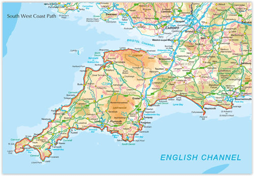
Productomschrijving: Omvat spectaculaire plaatsen die dit deel van het Engelse landschap rijk is, zoals Exmoor National Park, met 5 AONB's of Areas of Outstanding Natural Beauty, de Jurassic Coast Natural World Heritage Site. Deze route bestaat al heel lang. De route start of eindigd natuurlijk in Minehead, in Somerset, loopt langs de kust richting de volledige kust van Cornwall, en loopt verder langs de English channel tot in South Haven Point in Dorset. Langs de route zijn talrijke verblijfplaatsen en resto's, die ervoor zorgen dat u niet kunt tekort komen, althans niet als u de route volgt zoals die word voorgesteld.
Engelse omschrijving: Guidebook to walking the entire South West Coast Path National Trail. The route runs for 630 miles from Minehead to Poole along the north Devon, Cornish, south Devon and Dorset coastline. Divided into 45 stages, this long-distance coastal trek could be completed within 4 weeks, or walked in sections. Guide includes maps and essential information.
Seasons:
This National Trail may be walked year-round: be aware that winter accommodation availability may be limited, while high summer will be extremely busy and the weather often hot.
Centres:
Many centres are passed along the route, including Minehead, Lynmouth, Westward Ho!, Clovelly, Bude, Padstow, Newquay, St Ives, Penzance, Falmouth, Mevagissey, Polperro, Plymouth, Salcombe, Brixham, Portland, Swanage and Poole.
Difficulty:
The South West Coast path is a long walk! Most paths are easy to moderate, with some walks along rugged and exposed coastal cliff paths and some steep gradients.
Must See:
Exmoor National Park; 5 Areas of Outstanding Natural Beauty; the Jurassic Coast Natural World Heritage Site; numerous Heritage Coasts National and Local Nature Reserves, Sites of Special Scientific Interest and National Trust holdings.

Locatie op kaart
Gekoppelde artikelen

Wandelgids South West Coast Path North - Cicerone • 9781852849368
standaard versieWandelgids - South West Coast Path North - Cicerone Productomschrijving: Een eerste deel van het 1014km lange wandelpad die in deze gids loopt van Minehead tot St-Yves. Detail Uitgever: The South West Coast Path is Britain's longest National Trail, stretching some 630 miles (1014km) between Minehead in Somerset and Poole in Dorset. It takes in a National Park, 5 Areas of Outstanding Na…

Wandelgids South West Coast Path - Cicerone • 9781852849375
standaard versieWandelgids - South West Coast Path - Cicerone Productomschrijving: DEEL 2 - Dit deel betref het zuidelijke deel van de South west Coast path in Devon England - St-Ives to Plymouth Product description: The South West Coast Path is Britain's longest National Trail, stretching some 630 miles (1014km) between Minehead in Somerset and Poole in Dorset. It takes in a National Park, 5 Areas of…

Wandelgids South West Coast Path - Cicerone • 9781786312006
standaard versieMap booklet South West Coast Path - Cicerone Productomschrijving: Kaart van een deel van het zuidelijke deel van het 630 mijl (1014 km) lange South West Coast Path National Trail. Omvat het pad van Plymouth naar Poole langs de kustlijn van Devon en Dorset. Dit handige en compacte boekje met Ordnance Survey 1:25.000 kaarten toont de route en biedt alle kaarten die je nodig hebt om het pad i…
Artikelen uit dezelfde regio

Wandelgids Guide to the Cotswolds AONB - AA • 9780749579418
Wandelgids - Guide to the Cotswolds AONB - AA Productomschrijving: The Cotswolds zijn een regio van uitmuntend natuurlijk schoon, of in andere woorden, "Area of Outstanding Natural Beauty". Zo noemen de britten hun meest geliefde regio's. WIj spreken oven nationale parken or regionale parken, terwijl de britten er eveneens over beschikken, maar de AONB's gaan voor op de rest. Talloze route…

Wandelkaart 104 Redruth & St Agnes- Cornwall - OSI • 9780319243060
Wandelkaart Redruth & St Agnes - Cornwall England - OSI Omvat ook: Camborne & Perranporth. Productbeschrijving: Kaart nummer 104 in de OS Explorer kaart reeks is de ideale kaart voor wandelaars, fietsers en vakantiegangers die een bezoek willen brengen aan Redruth en St. Agnes. De Cornishe kustlijn die domineert op dit gebied is perfect voor liefhebbers van het buitenleven en heeft vel…

Wandelkaart 102 Land's End - OSI • 9780319263648
Wandelkaart 102 Explorer Land's End - OSI Productomschrijving: Kaart nummer 102 in de OS Explorer kaartenserie is de perfecte kaart voor het ontdekken van het beroemde gebied rond Land's End, Penzance en St Ives. Het gebied staat bekend als het meest extreem zuidwestelijke punt van Groot-Brittannië. Hoogtepunten zijn: Penzance, Land's End, Mousehole, en Cape Cornwall. Inclusief mobiele…

Wandelgids Dartmoor National Park - Cicerone • 9781786311085
Dartmoor National Park - Cicerone Productomschrijving: Deze wandelgids bevat routebeschrijvingen voor 42 dagwandelingen in het Dartmoor National Park en omgeving. De wandelingen variëren allemaal in lengte van 3.5 tot 17 Km en elke route is ingedeeld naar moeilijkheidsgraad van gemakkelijk tot matig of zwaar. De meeste wandelingen zijn rondwandelingen met enkele langere routes die lineair …

Wandelkaart 194 Dorchester & Weymouth Dorset - OSI • 9780319262924
Wandelkaart Dorchester & Weymouth - Dorset England Productbeschrijving: Landranger kaart 194 behandelt de zandstranden en de glooiende heuvels van kust van Dorset. U kunt het South West Coast Path nemen, voor mooie uitzichten over het kanaal en de verschillende geologie van de Jurassic kustlijn en de kalksteen van de Isle of Portland. De OS Landranger kaarten reeks heeft betrekking op …