
Reisgids Scottish Highlands & Islands - Rough guides
A fully updated The Rough Guide to Scottish Highlands
Korte omschrijving
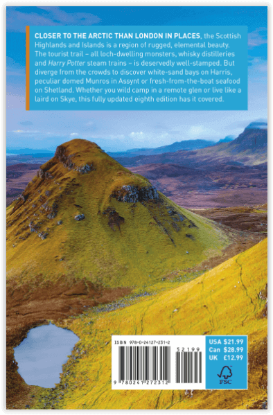
Scottish Highlands & Islands - Rough guides Product description: This fully updated The Rough Guide to Scottish Highlands and Islands is the ultimate guidebook to the captivating remote reac...

Specificaties
- Uitgever: Rough Guides
- ISBN-13: 9780241272312
- HOOFDCATEGORIEËN: Reisgids
- Activiteiten: Toerisme
- Regio: Highlands, Schotland, Inner hybrids (Binnen-Hebriden), Schotland, Outer Hibrids, Schetland Islands, Schotland
- Land: Schotland
- Blz.: 440
- Afmeting: 13x20
- Editie: 8
- Taal: Engels
Volledige omschrijving
Scottish Highlands & Islands - Rough guides
Product description: This fully updated The Rough Guide to Scottish Highlands and Islands is the ultimate guidebook to the captivating remote reaches of Scotland. From the divine seafood offerings at Loch Fyne to the whisky distilleries on Islay, this is a place for indulging. It’s also a hotspot for outdoor activities, whether you decide to bag a Munro or two, hop onto a mountain bike or stroll along deserted (if blustery) golden beaches.
The Rough Guide to Scottish Highlands and Islands contains more information than ever on where to go and what to see in this part of Scotland, with practical information on everything from events listings to transport logistics. There’s also coverage of the brand new North Coast 500 route, which loops around the northernmost reaches of the country.
From Skye’s breathtaking Cuillin ridge to abandoned castles, via riproaring unplanned ceilidhs, this stark and weather beaten part of the planet will not disappoint.
Locatie op kaart
Artikelen uit dezelfde regio

Wandelkaart 352 Islay South Inner Hybrids Schotland- OSI • 9780319472231
Wandelkaart Islay South - Inner Hybrids Schotland Omvat ook: Port Ellen, Bowmore & Bridgend. Productbeschrijving: De zuidelijke helft van Islay op de Binnen-Hebriden, omvat OS Explorer kaart blad 352 omvat ook het eiland ''capital', Bowmore. U kunt poort Ellen en het schiereiland van Oa ook gaan verkennen. De OS Explorer kaart voor Islay zuid is beschikbaar in zowel de standaard papier…

Wandelkaart 35 Kingussie & Cairngorms NP - Highland's - OSI • 9780319261330
Wandelkaart Kingussie & Monadhliath - Cairngorms NP Schotland Productbeschrijving: De OS Landranger kaarten reeks heeft betrekking op Groot-Brittannië met 204 gedetailleerde kaarten, perfect voor dagtochten en korte pauzes. Elke kaart bevat alle informatie die u nodig heeft om dit lokaal gebied te leren kennen en omvat plaatsen van belang, toeristische informatie, picknickplaatsen en campi…

Wandelkaart 431Glen Urquhart & Strathglass - OSI • 9780319246634
Wandelkaart Glen Urquhart & Strathglass - Highlands Schotland Productbeschrijving: Drumnadrochit & Muir of Ord. 431 / Glen Urquhart & Strathglass, Highlands, Schotland - Ten westen van de Highalnd hoofdstad Inverness, omvat deze OS Explorer kaart 431 Drumnadrochit north to Muir of Ord. Het omvat de nationale Scenic gebied van Strathfarrar, Orrin Reservoir, en een kleine hoeveelheid va…

Wandelkaart 391 Ardgour & Strontian Highlands - OSI • 9780319246344
Wandelkaart Ardgour & Strontian - Highlands Schotland Productbeschrijving: Glenfinnan, Loch Eil & Loch Shiel 391 Ardgour / Strontian, Highlands Schotland - Kaart nummer 391 in de OS Explorer kaart reeks is ideaal voor ontdekken van het gebied in de buurt van Ben Nevis. Loch Linnhe, en ligt ten westen van Ben Nevis en Glen Coe met prachtige landschappen en uitdagende wandelingen, die er…

Wandelkaart Ben Venue Loch Ard and Trossachs - Harvey maps • 9781851374618
Wandelkaart Ben Venue Loch Ard and Trossachs - Harvey maps Productomschrijving: Ben Venue met inbegrip van Loch Ard Forest deze kaart beslaat het gebied ten westen van Callander in het zuidoostelijke deel van het Nationaal Park, met inbegrip van Ben Venue, Loch Ard bos en de Trossachs. Loch Ard Forest is op grote schaal gebruikt voor mountainbiken en routes worden weergegeven op de kaart. …