
Wandelkaart 245 Black Canyon of the Gunnison NP - Natgeo
Een nationaal park in het westen van het Amerikaanse Colorado
Korte omschrijving
TOPO Wandelkaart 245 - Black Canyon of the Gunnison NP - Nat Geo Productomschrijving: Het Black Canyon of the Gunnison National Park is een nationaal park in het westen van de Amerikaanse s...

Specificaties
- Uitgever: National Geographic
- ISBN-13: 9781566953689
- HOOFDCATEGORIEËN: Wandelkaart
- Activiteiten: Wandelen, Hiking & Trekking
- Regio: Colorado, USA
- Land: Verenigde Staten van Amerika (USA)
- Nationale parken: Black Canyon of the Gunnison NP, Colorado USA
- Schaal: 1:63360
- Afmeting: 10x19
- Taal: Engels
Volledige omschrijving
TOPO Wandelkaart 245 - Black Canyon of the Gunnison NP - Nat Geo
Productomschrijving: Het Black Canyon of the Gunnison National Park is een nationaal park in het westen van de Amerikaanse staat Colorado. Het beschermt 19 km van de 77 km lange kloof van de Gunnison River, een zijrivier van de Colorado River.
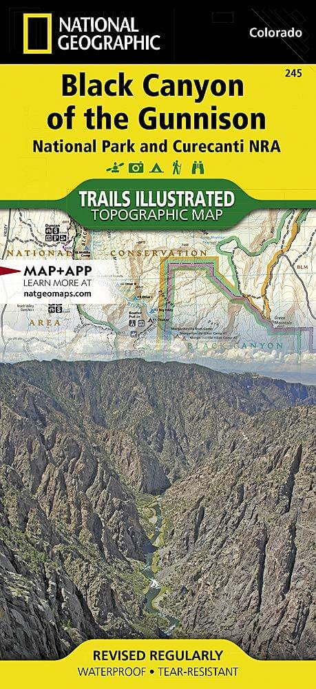
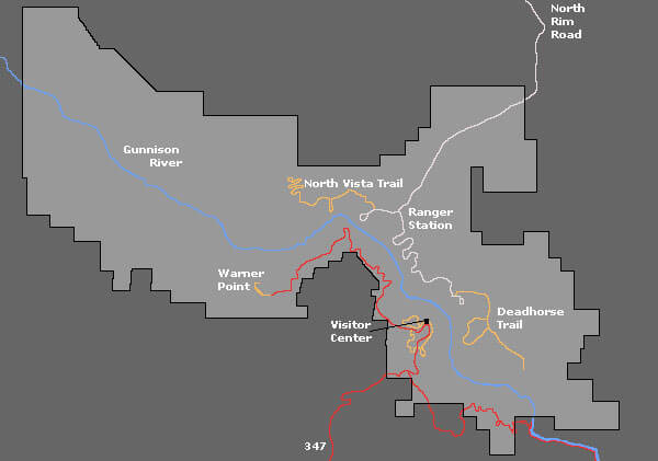
Engelse omschrijving: The Black Canyon, 48 miles of awe-inspiring, steep-walled canyon carved by the Gunnison River, has been an obstacle and attraction to residents and visitors alike for centuries. National Geographic's Trails Illustrated map of Black Canyon of the Gunnison National Park and Curecanti National Recreation Area delivers unmatched detail and valuable information to assist you in your exploration of this breathtaking wilderness. Expertly researched and created in partnership with local land management agencies, this map includes Gunnison Gorge National Conservation Area; Blue Mesa Reservoir; portions of Gunnison National Forest and West Elk Wilderness; and the towns of Montrose, Paonia, and Hotchkiss.
Designed with a wide range of visitors in mind, this map features detailed and easy-to-read trails, accurate road network, and a variety of information about the region and recreational activities available, including hiking trail summaries for the north and south rims of the canyon. Trail use is easy to identify, whether you're traveling on foot, horse, OHV, or snowmobile. Road types are differentiated as well, so you know if the route you choose is a four-wheel-drive or high-clearance road. The West Elk Loop and Silver Thread scenic byways are noted for those wishing to take in the scenery by car. Campgrounds, fishing areas, boat ramps, river access, and primitive campsites for hikers and boaters throughout the park are shown, as well as rapids and ratings along the Gunnison River. The map base includes contour lines and elevations for summits, passes and many lakes.
Locatie op kaart
Overzichtskaarten

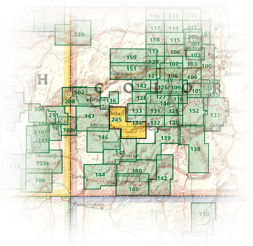
NAT GEO Colorado trail maps
NAT GEO Colorado trail maps

Producten op de overzichtskaart
Klik op een product om naar de detailpagina te gaan.
- Wandelkaart 110 Leadville & Fairplay - Colorado - Nat Geo
- Wandelkaart 127 Aspen - Independence Pass - Colorado USA
- Wandelkaart 137 Pikes Peak & Cañon City - Nat Geo
- Wandelkaart 138 Sangre de Cristo Mountains - Nat Geo
- Wandelkaart 139 La Garita Caldera - Cochetopa - Nat Geo
- Wandelkaart 140 Weminuche Wilderness Colorado USA - Nat Geo
- Wandelkaart 141 Telluride- Silverton- Ouray & Lake City - Nat Geo
- Wandelkaart 144 Durango & Cortez- Colorado - Natgeo
- Wandelkaart 200 Rocky Mountain NP- Colorado - Nat Geo
- Wandelkaart 208 Colorado National Monument - Natgeo
- Wandelkaart 245 Black Canyon of the Gunnison NP - Natgeo
- Wandelkaart 301 Longs Peak -Trails Illustrated N. Trails - Nat Geo
- Wandelkaart 601 Aspen Local Trails - Nat Geo
Artikelen uit dezelfde regio

Wandelkaart 103 Winter Park, Central City & Rollins Pass • 9781566952767
Wandelkaart Winter Park, Central City & Rollins Pass Productomschrijving: National Geographic's Trails Illustrated kaart van Winter Park, Central City en Rollins Pass biedt ongeëvenaarde details voor outdoor enthousiastelingen die het hele jaar door willen genieten van de recreatieve mogelijkheden in de zuidelijke delen van Roosevelt en Arapaho National Forest. Deskundig onderzocht en gema…

Wandelkaart 141 Telluride- Silverton- Ouray & Lake City - Nat Geo • 9781566953405
Wandelkaart Telluride- Silverton- Ouray & Lake City - Nat Geo Productomschrijving: De National Geographic Trails Illustrated kaart van Telluride, Silverton, Ouray, en Lake City is deskundig onderzocht en gemaakt in samenwerking met lokale landbeheerders. Het is een ongeëvenaard hulpmiddel voor het verkennen van deze adembenemende regio van Colorado. Ongeacht het seizoen is deze kaart een h…

Wandelkaart 1303 Colorado 14ers- Zuid - Nat geo • 9781566957007
TOPO Wandelkaart 1303 - Colorado 14ers- Zuid - Natgeo Productomschrijving: De colorad 14'ers Zuid, zijn de 14 meest indrukwekkende bergmassieven in het zuiden van Colorado. De locatie is onderverdeeld in drie regio's zoals: De Elk Range, San Juan Range & Sangre De Cristo Range. Elk Range: Capitol Peak, Castle Peak, Conundrum Peak, Maroon Peak, North Maroon Peak, Pyramid Peak, Snowmass …

Wandelkaart 128 Maroon Bells- Redstond & Marble - Nat Geo • 9781566952484
TOPO Wandelkaart 128 - Maroon Bells- Redstond & Marble - National Geographic Productomschrijving: De Maroon Bells zijn 2 bergtoppen in de Elk Mountains, Maroon Peak & North Maroon Peak, met een dikke half kilometer gescheiden. De liggen liggen op de grens tussen Pitkin County & Gunnison County, Colorado, United States Engelse omschrijving: Colorado's Maroon Bells are the most photograp…

Wandelkaart 127 Aspen - Independence Pass - Colorado USA • 9781566953580
TOPO Wandelkaart 127 - Aspen - Independence Pass - Colorado USA Productomschrijving: Independence Pass in Aspen Colorado is een uitmuntende wandellocatie. Deze omvat een topografische wandelkaart die echt tot de verbeelding spreekt. Een subliem exemplaar als het over wandelen gaat. Engelse omschrijving: Independence Pass, originally known as Hunter Pass, is a high mountain pass in cen…