
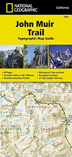
Wandelkaart 1001 - John Muir Trail - Nat Geo
Doorkruist Yosemite- Kings Canyon en Sequoia National Park
Korte omschrijving
TOPO Wandelkaart 1001 - John Muir Trail - National Geographic Productomschrijving: De John Muir Trail - is een langeafstandswandelpad in het Sierra Nevada-gebergte in de Amerikaanse staat Ca...

Specificaties
- Uitgever: National Geographic
- ISBN-13: 9781566956895
- HOOFDCATEGORIEËN: Wandelkaart
- Activiteiten: Wandelen, Hiking & Trekking
- Regio: Californië, USA
- Land: Verenigde Staten van Amerika (USA)
- Lange afstand wandelroutes: John Muir Way (215 km)
- Blz.: 48
- Schaal: 1:63360
- Afmeting: 10x19
- Taal: Engels
Volledige omschrijving
TOPO Wandelkaart 1001 - John Muir Trail - National Geographic
Productomschrijving: De John Muir Trail - is een langeafstandswandelpad in het Sierra Nevada-gebergte in de Amerikaanse staat Californië. Het is vernoemd naar de Schots-Amerikaanse natuurvorser en schrijver John Muir, die een cruciale rol speelde in de bescherming van de nationale parken van Californië. Het 338,6 kilometer lange pad doorkruist Yosemite, Kings Canyon en Sequoia National Park. Het merendeel van het pad (zo'n 260 km) valt samen met de Pacific Crest Trail, dat van de Mexicaanse grens naar de Canadese loopt.
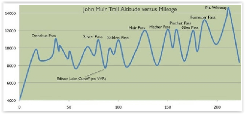
Engelse omschrijving: National Geographic's Map Guide of the John Muir Trail is an indispensable tool for navigating one of the most famous trails in the United States. Expertly researched and created in partnership with local land management agencies, this product provides detailed topographic maps, interesting history, a waypoint table, information about wilderness safety, and key points of interest you will encounter along the trail. A resupply location chart shows shipping address/contact information, distances, and services available at each resupply point. Each map page has a detailed trail profile that shows the elevation changes you will encounter. Also, the John Muir Trail is highlighted and centered on each page so you can easily track your progress.
The maps start at the northern terminus in Yosemite Valley and progress along the ridge of the Sierra Nevada, past Devils Postpile, and end at the highest point in the lower 48 on the top of Mount Whitney. Along the way you will pass through; Yosemite National Park, Ansel Adams Wilderness, Devils Postpile National Monument, John Muir Wilderness, Kings Canyon National Park, and finally, Sequoia National Park and Mount Whitney. A 21-day sample itinerary is included as well. Every Topographic Map Guide is printed on "Backcountry Tough" waterproof, tear-resistant paper. A full UTM grid is printed on the map to aid with GPS navigation.
Other features found on this map include: Ansel Adams Wilderness, Bridalveil Fall, El Capitan, Illilouette Falls, Inyo National Forest, John Muir Wilderness, Kings Canyon National Park, Lake Thomas A Edison, Lower Yosemite Fall, Middle Palisade, Mount Agassiz, Mount Darwin, Mount Muir, Mount Pinchot, Mount Powell, Mount Ritter, Mount Russell, Mount Tyndall, Mount Whitney, Mount Williamson, Nevada Fall, North Palisade, Ribbon Fall, Ritter Range, Sequoia National Park, Sierra National Forest, Sierra Nevada, Split Mountain, Upper Yosemite Falls, Vernal Fall, Yosemite National Park, Yosemite Valley.
.png)
Locatie op kaart
Artikelen uit dezelfde regio

Wandelkaart 803 Lake Tahoe Basin - California - Nat Geo • 9781566953344
TOPO Wandelkaart 803 - Lake Tahoe Basin - California - Nat Geo Productomschrijving: Lake Tahoe Basin is een bosgebied in het Sierra Nevada-gebergte in de Verenigde Staten, dat als National Forest. Het bosgebied ligt verspreid over Placer, El Dorado en Alpine County in Californië en Washoe en Douglas County en Carson City in Nevada. Engelse omschrijving: The largest alpine lake in North…

Wandelgids California & Southwest USA's NP's - Lonely Planet • 9781838696061
Wandelgids California & Southwest USA's National Parks Productomschrijving: Lonely Planet's California and Southwest USA's National Parks is uw paspoort voor het meest actuele advies over wat je moet zien en overslaan. Wandel door de Grand Canyon, bewonder Sequoia en jaag op watervallen in Yosemite; allemaal met je vertrouwde reisgenoot. Duik in het hart van de nationale parken van Califor…

Reisgids San Francisco pocket guide - Lonely Planet • 9781787014114
San Francisco pocket guide - Lonely Planet Coverage Includes: Golden Gate Bridge, The Marina, Fisherman’s Wharf, North Beach, Chinatown, Downtown, SoMa, Hayes Valley, Civic Center, The Mission, The Haight, Golden Gate Park, and more Product description: Lonely Planet Pocket San Francisco is your passport to the most relevant, up-to-date advice on what to see and skip, and what hidden d…

Wandelkaart 221 Death Valley NP - Nevada - Natgeo • 9781566953214
TOPO Wandelkaart 221 - Death Valley NP - Nevada - Nat Geo Productomschrijving: Death Valley National Park is een Amerikaans nationaal park die de California—Nevada grens aanraakt, ten oosten van de Sierra Nevada. De grenzen omvatten Death Valley, het noordelijk deel van Panamint Valley, het zuidelijk deel van Eureka Valley, en het de meerderheid van Saline Valley. Engelse omschrijving…

Wandelkaart 252 Channel Islands National Park - Nat Geo • 9781566954105
Channel Islands National Park - Nat Geo Productomschrijving: De Channel Islands Nationaal Park, gelegen voor de kust van Californië, zijn de thuisbasis van vele unieke soorten flora en fauna. National Geographic's Trails Illustrated kaart van Channel Islands National Park bestrijkt met ongeëvenaard detail de vijf eilanden die het park omvat, inclusief The Nature Conservancy gebied van Sant…